Without a doubt, the pandemic has had an unprecedented impact on local economies. Many businesses have had to shutter their storefronts and few developers have had the wherewithal to follow through with or begin new projects. But economists suggest brighter days are ahead.
Now is the time for communities to think about how to build a successful recovery and which tools will be helpful to achieving their goals. One such tool that some local governments are finding useful is something called “story maps.”
What are story maps?
Story maps provide an innovative and creatively compelling communication vehicle for local governments to explain and engage with the community-at-large about a planning process or opportunities for development. By combining narrative text and other multimedia content with Geographic Information System (GIS) maps and data, story maps serve as an effective means of helping residents and developers visualize and understand projects with greater clarity.
Every community has a story to tell
Story mapping enables planners or others engaged with economic development to centralize and present in-depth community data more powerfully to stimulate public involvement and support. It’s an imaginative platform that makes it possible to connect stories or scenarios that are happening within a community with their geographic spaces.
For instance, there might be an area in a community that’s been rich in cultural history, but needs a boost to draw new business and tourism. Using the story map concept, the story of that neighborhood’s significance – as an arts community or its particular historical or ethnic importance – is connected with an interactive map to provide location-based context. It allows viewers or readers to see that area for all its complex value.
Story maps offer opportunities to:
- Show the correlations among multiple issues, such as housing, transportation, and education
- Help humanize and visualize abstract ideas
- Reach a wide audience and provide a platform for interactions among community members, as well as other stakeholders, such as local governments, planners, or developers
- Help outside stakeholders identify key community resources, assets and experiences that can inform planning and policy-making.
Who’s using story maps for economic development?
A quick Google search will bring up an extensive list of examples of local governments and government agencies putting story maps to work, including some General Code client communities:
Rising and thriving
As communities emerge and begin to move on from the most recent economic challenges, it’s important to seek innovative opportunities to collaborate and think forward. Solutions and partners that can support your community’s vision for the future are vital to rising up from the recent crises to build thriving, resilient communities.
Whether it’s employing story maps, implementing interactive zoning maps, or making zoning codes easier to understand with enhanced graphics, communities have never had so many valuable tools to help boost development and growth.
How can we help you?
Do you have questions about any of our services? Find out how we can build vibrant, resilient communities together. Contact us at 800.836.8834 or email us at [email protected]. You can also fill out our Solution Inquiry form. We’d be happy to hear from you.
Resources:
On the Post-Pandemic Horizon, Could That Be … a Boom?
The Trust for Public Land – Planning and GIS – Story Maps Project Gallery
LOC Geography and Maps Reading Room – Story Maps
FEMA – Hazard Mitigation Planning and Resilient Communities Story Maps
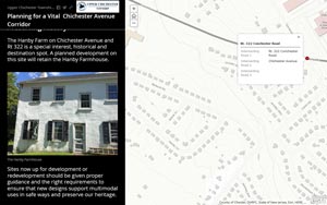
Planning for a Vital Chichester Avenue Corridor